


Walks up to 2 miles
-
Miles without stiles - Malham Cove
Starting at the National Park Centre, follow the road through the village. At the phone box, go through the gate to follow the unsurfaced woodland trail alongside the stream then continue on the road to just beyond Town Head Barn where the gradient reaches 1 in 6.
The footpath to the cove is a well-surfaced track of compact stone with a general width of at least 150cm. The first 25m of the route has a gradient of 1 in 6. From here, the footpath levels out and does not exceed a 1 in 8.
From the beginning of April to the end of August, wardens and volunteers from both the RSPB and the Yorkshire Dales National Park Authority are present near the Cove to show visitors some of the exciting birds that can be found in the Yorkshire Dales.
Distance: 0-2 Miles
Features: Accessible route
Location: Malhamdale
-
Miles without stiles - Buckden
Follow the steep footpath out of the car park. Cross the road and carry on down the unsurfaced track to reach Dubbs Lane. From here follow the road across the river. The two routes start on either side of the road once over the bridge.
Walking south, this 1km level footpath runs alongside the River Wharfe. The surface is constructed of a mixture of stone flags, aggregate and grass with a general width of 1m. Walking north, the footpath is a mixture of grass and compact aggregate.
Whilst walking beside the River Wharfe, look out for kingfisher, oystercatcher, dipper and sand martin.
Distance: 0-2 Miles
Features: Accessible route
Location: Wharfedale
-
Miles without stiles - River Rawthey
Starting from the Joss Lane car park in Sedbergh, turn left and follow the footpath to join Long Lane. Turn left onto Long Lane and cross the road at the zebra crossing by the police station. Turn right onto the A684 and follow the footpath to the school entrance. From here the surface is a mixture of concrete and compact earth with a general width of 100cm. There is one accessible kissing gate along the length of the route. The section of the footpath along the river is relatively flat. However, the descent from Settlebeck School has gradients reaching 1:7.
Whilst walking along the river, look out for heron, dipper and goosander as well as nuthatch, tree creeper and long-tailed tit in the trees and hedges. In the late autumn look out for salmon jumping at the weir.
Distance: 0-2 Miles
Features: Accessible route
Location: Lune Valley; Rawthey Valley
-
A walk along the valley bottom from Sedbergh including a lovely riverside section.
Distance: 0-2 Miles
Features: Low level route (mostly valleys)
Location: Dentdale; Garsdale
-
An easy access route from Reeth to the River Swale.
Starting on the village green, take the flagged alleyway between the Black Bull and Kings Arms public houses. After 40m the alleyway turns into a tarmacked lane leading to Langhorne Drive. Turn left onto Langthorne Drive and then right at the end following the signpost to the Swing Bridge. From here the route is unsurfaced with some gradients reaching 1:6.
Whilst walking along the river, look out and listen for heron and dipper on the river as well as nuthatch, tree creeper and greate spotted woodpecker in the trees along the river bank.
Distance: 0-2 Miles
Features: Accessible route
Location: Swaledale
-
Starting at the car park, follow the road through Hawes, crossing Gayle Beck. After approximately 60m from the bridge, turn left up the cobbled footpath signposted to Gayle. The next 70m of this route are cobbled with a gradient of 1:7. After this point, the footpath levels out with some slight gradients up to 1:10. Most of the length is constructed of stone flags at a width of 100cm. There is a rest area halfway along the route.
Distance: 0-2 Miles
Features: Accessible route
Location: Wensleydale
-
Miles without stiles - Aysgarth Falls
The first 500m of this 1.5km footpath runs through Freeholders’ Wood and has great views of the Middle Falls. The surface here is compact aggregate and the width of the footpath is at least 100cm. All gates are fully accessible and there are benches along the route.
From here, a flight of seventy steps provide access to the Lower Falls. Alternatively, the footpath continues for a further 1km along an unsurfaced grass route.
A further 600m route can be followed from the start along an
unsurfaced track through the woodland.
Distance: 0-2 Miles
Features: Accessible route
Location: Wensleydale
-
Walk - Aysgarth woods and waterfalls
A short walk through the woods and returning by the spectacular Aysgarth Falls.
Distance: 0-2 Miles
Features: Low level route (mostly valleys)
Location: Wensleydale
-
An audio trail exploring the stunning Ribblehead viaduct and the history of its construction
Distance: 0-2 Miles
Location: Chapel-le-Dale; Ribblesdale
-
Miles without stiles - Cotter Force
Known as ‘the valley of the waterfalls’, Wensleydale harbours many delights for the visitor. Cotter Force, west of Hawes, is a lovely secluded waterfall in a wooded setting. It is a series of about six waterfalls with the largest single drop being about 1.5m. This 490m level footpath alongside the beck is constructed of compact stone with a general width of 100cm. There are three benches evenly spaced along the footpath.
Whilst walking the route look out for dippers, grey wagtails, redstarts, long tailed tits and kingfishers.
Distance: 0-2 Miles
Features: Accessible route
Location: Wensleydale
-
Walk - Stainforth and Catrigg Force
One of the Dales lesser known waterfalls is visited on this lovely short circular walk.
Distance: 0-2 Miles
Features: Low level route (mostly valleys)
Location: Ribblesdale
-
Miles without stiles - Killington
An easy access walk alongside the River Lune not far from Sedbergh.
Killington New Bridge Local Nature Reserve is owned and managed by the Yorkshire Dales National Park Authority. It consists of a steep woodland bank running down to the River Lune which flattens out at the top to provide a narrow strip of grassland, scrub and diverse hedge which is partially laid. Salmon occur in the river and there is a strong likelihood that mammals such as otter and badger use the wood.
Access to this 575m level footpath is through an accessible kissing gate. The surface is constructed of compacted aggregate with a general width of 120cm.
Distance: 0-2 Miles
Features: Accessible route
Location: Lune Valley
-
Miles without stiles - Grinton
Grinton is one of the 87 lead smelt mill sites known in the Yorkshire Dales. It is of national importance and is a scheduled monument.
This 750m route runs from the Grinton to Leyburn road to the remains of the smelt mill and back again. The track is a compact mix of aggregate and grass with a general width of 200cm. The track to the smelt mill has some gradients reaching 1:8. There is a small add on loop at the end of the route. This requires a shallow water crossing and a short, 60m, gradient of 1:6.
Distance: 0-2 Miles
Features: Accessible route
Location: Swaledale
-
A short circular walk that takes you past the Castle Haw castle site, and provides wonderful views over Sedbergh and the valley.
Distance: 0-2 Miles
Features: Low level route (mostly valleys)
Location: Garsdale; Lune Valley
-
A short circular walk giving great views over this part of Swaledale.
Distance: 0-2 Miles
Features: Low level route (mostly valleys)
Location: Swaledale
-
Miles without stiles - Malham Tarn
This 2.5km footpath starts at the National Trust car park. The first 500m of the route are rough grass up to a gradient of 1:10. From here, the route joins a well-surfaced track with a general width of at least 300cm. There is a wheelchair accessible boardwalk loop providing access to the nature reserve at the Water Houses end.
The tarn is said to be the highest marl lake in Britain and is rich in submerged aquatic plants. Whilst walking round the lake, look out and listen for great crested grebe, moorhen, coot, tufted duck and teal.
Distance: 0-2 Miles
Features: Accessible route
Location: Malhamdale
-
Miles without stiles - Burnsall
An easy access route starting in Burnsall and following the River Wharfe.
A 700m length of a popular section of the Dales Way runs between the village of Burnsall and Loup Scar. The route is well surfaced and level. There are two kissing gates along its length which can be difficult for scooters.
Whilst walking along the river, look out for pied and grey wagtail, dipper, common sandpiper and oystercatcher.
Distance: 0-2 Miles
Features: Accessible route
Location: Wharfedale
-
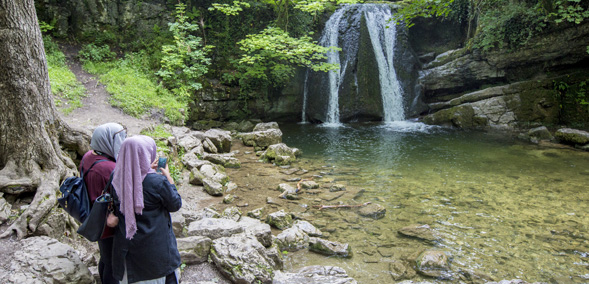
Miles without stiles - Gordale Scar
An easy access route into the towering cliffs of Gordale Scar.
This 600m footpath runs from Gordale Bridge to Gordale Scar. The route is well surfaced and level and has a general width of 100cm.
Whilst walking the route, look out for peregrines and dippers.
Distance: 0-2 Miles
Features: Accessible route
Location: Malhamdale
-
A short circular walk taking in the River Lune, Devil's Bridge and Kirkby Lonsdale
Distance: 0-2 Miles
Features: Accessible route
Location: Lune Valley
-
Miles without stiles - Grassington
An easy access walk by the River Wharfe close to the lovely village of Grassington.
A gate at the lower end of the car park gives access to a walled lane. The route here is well-surfaced with some gradients reaching a 1:7. Follow the river to the right along an unsurfaced route. From here, turn right onto the main road into Grassington where the first 50m are a 1:6 gradient.
Take a moment to look at Linton Falls when by the river. The falls mark the line of the North Craven Fault.
Distance: 0-2 Miles; 3-5 Miles
Features: Accessible route
Location: Wharfedale
-
Miles without stiles - Bolton Abbey
An easy access walk at the delightful Bolton Abbey alongside the River Wharfe.
For the first 1.8km of the route, the surface is compact stone at a width of at least 200cm. There are passing places and accessible benches along the full length of the route. Most of the route is flat with some areas having a gradient up to 1:10. From here, the route is unsurfaced with some gradients reaching 1:6.
Distance: 0-2 Miles; 3-5 Miles
Features: Accessible route
Location: Wharfedale
Walks 3-5 miles
-
Miles without stiles - Bolton Abbey
An easy access walk at the delightful Bolton Abbey alongside the River Wharfe.
For the first 1.8km of the route, the surface is compact stone at a width of at least 200cm. There are passing places and accessible benches along the full length of the route. Most of the route is flat with some areas having a gradient up to 1:10. From here, the route is unsurfaced with some gradients reaching 1:6.
Distance: 0-2 Miles; 3-5 Miles
Features: Accessible route
Location: Wharfedale
-
Miles without stiles - Grassington
An easy access walk by the River Wharfe close to the lovely village of Grassington.
A gate at the lower end of the car park gives access to a walled lane. The route here is well-surfaced with some gradients reaching a 1:7. Follow the river to the right along an unsurfaced route. From here, turn right onto the main road into Grassington where the first 50m are a 1:6 gradient.
Take a moment to look at Linton Falls when by the river. The falls mark the line of the North Craven Fault.
Distance: 0-2 Miles; 3-5 Miles
Features: Accessible route
Location: Wharfedale
-
A short circular walk from Reeth to Healaugh in Swaledale, with a return along the riverside.
Distance: 3-5 Miles
Features: Low level route (mostly valleys)
Location: Swaledale
-
Walk - Muker, Keld and the Corpse Way
A fantastic walk through upper Swaledale visiting villages, waterfalls and passing through the meadows that make the area famous.
Distance: 3-5 Miles
Features: Low level route (mostly valleys)
Location: Swaledale
-
Walk - Settle and Attermire Scar
Hidden behind the town of Settle is the beautiful area of Attermire Scar with the important site of Victoria Cave.
Distance: 3-5 Miles
Features: Low level route (mostly valleys); High level route (visits fellsides)
Location: Ribblesdale
-
A circular walk using the Pennine Way and open access land with views of Malham Tarn.
Distance: 3-5 Miles
Features:
Location: Malhamdale
-
A classic walk along the River Wharfe, taking in Linton Falls, Gaistrills Strid and the lovely Grass Woods.
Distance: 3-5 Miles
Features: Low level route (mostly valleys)
Location: Wharfedale
-
Walk - Kettlewell to Starbotton
A wonderful Wharfedale circuit high along the valley and then back along the river.
Distance: 3-5 Miles
Features: High level route (visits fellsides)
Location: Wharfedale
-
Distance: 3-5 Miles
Location: Wharfedale
-
A circuit around the stunning Malham Tarn taking advantage of National Trust owned open access land.
Distance: 3-5 Miles
Features: Low level route (mostly valleys); High level route (visits fellsides)
Location: Malhamdale
-
Miles without stiles - Grimwith
An easy access walk around Grimwith Reservoir high in the Yorkshire Dales.
The route to the east follows a well-surfaced track to a width of at least 200cm. There are some gradients reaching 1:8 to access the water’s edge but most of the route is relatively flat. The first section of the route to the west passes over the dam and is unsurfaced. From here, the track is surfaced with some gradients reaching a 1:6.
Grimwith Reservoir is one of the best places to see wildfowl in the Yorkshire Dales so take along your binoculars and you might see wigeon, teal, greylag and Canada geese on the water.
Distance: 3-5 Miles
Features: Accessible route
Location: Wharfedale
-
A short circular walk between Grassington and a lovely Dales village, Hebden.
Distance: 3-5 Miles
Features: Low level route (mostly valleys)
Location: Wharfedale
-
A walk linking two lovely villages - Buckden and Starbotton, going along the valley side and back along the river.
Distance: 3-5 Miles
Features: Low level route (mostly valleys)
Location: Wharfedale
-
A selection of three short walks near Ingleton exploring the countryside and finding the Sherlock connections.
Distance: 3-5 Miles
Features:
Location: Chapel-le-Dale; Kingsdale; Ribblesdale
-
Walk - Hawes and Aysgill Force
This walk takes you past the home of Wensleydale cheese, through the tiny streets of Gayle and up to the lovely waterfall of Aysgill Force.
Distance: 3-5 Miles
Features: Low level route (mostly valleys)
Location: Wensleydale
-
Miles without stiles - Ivelet Moor
An easy access walk with tremendous views of Swaledale.
This 11km route follows a well-surfaced track over the heather moorland. The route is at least 200cm wide with some short sections of gradients reaching 1:6.
Whilst walking, look out and listen for moorland birds including red grouse, meadow pipit, golden plover, curlew, lapwing and skylark.
Distance: 3-5 Miles
Features: Accessible route
Location: Swaledale
-
Miles without stiles - Old Gang
An easy access walk close to Reeth which takes you to the remains of the Old Gang lead mine workings.
The smelt mill at Old Gang, in Arkengarthdale, was built in the early nineteenth century. A huge open-sided peat house, reputed to hold three years’ worth of fuel, was built nearby.
The first 3km of the route runs alongside Old Gang Beck to the remains of Old Gang Smelt Mill. The track to the smelt mill is at least 200cm wide and is surfaced with a well-compacted aggregate. The steepest gradient is a 1:10. From here the track becomes more undulating but the views along Swaledale are well worth it for those who like a challenge.
Whilst there, look out and listen for buzzard and raven in flight.
Distance: 3-5 Miles
Features: Accessible route
Location: Swaledale
-
A short walk visiting the nearby village of Sedbusk, and the hamlet of Hardraw where you can visit the spectacular Hardraw Force.
Distance: 3-5 Miles
Features: Low level route (mostly valleys)
Location: Wensleydale
-
An audio trail in Wensleydale exploring the villages of Askrigg and Bainbridge
Distance: 3-5 Miles
Location: Wensleydale
-
A very accessible longer walk which uses a section of old railway line to take you to the superb Smardale Gill nature reserve.
Distance: 3-5 Miles
Features: Accessible route
Location: Orton Fells
-
A chance to see the quieter side of Malham with a walk over the moors above the Tarn.
Distance: 3-5 Miles
Features: High level route (visits fellsides)
Location: Malhamdale
-
An audio trail in upper Swaledale discovering the village of Muker and the River Swale
Distance: 3-5 Miles
Location: Swaledale
-
Walk - Buckden, Cray and Hubberholme
A longer walk taking in a lovely high traverse in upper Wharfedale.
Distance: 3-5 Miles
Features: High level route (visits fellsides)
Location: Langstrothdale; Wharfedale
-
A super walk climbing from the pretty village of Orton up to Beacon Fell Monument.
Distance: 3-5 Miles
Features: High level route (visits fellsides)
Location: Orton Fells
-
An audio trail from the village of Stainforth taking in Stainforth Foss, Langcliffe and the Hoffman Kiln
Distance: 3-5 Miles
Location: Ribblesdale
-
Distance: 3-5 Miles
Location: Langstrothdale
-
A walk through the meadows above the Wharfedale town of Grassington.
Distance: 3-5 Miles
Features: Low level route (mostly valleys)
Location: Wharfedale
-
A classic Dales walk taking in Janet’s Foss and the majestic Malham Cove. A short side trip can be made to include a visit to Gordale Scar.
Distance: 3-5 Miles
Features: Low level route (mostly valleys)
Location: Malhamdale
Walks 6-10 miles
-
Linear walk - Bolton Abbey to Grassington
Try something a little different with this nine mile one-way walk along riverside pastures to Grassington. You can then catch the bus back to Bolton Abbey. For public transport details see Traveline Yorkshire.
Distance: 6-10 Miles
Features: Low level route (mostly valleys)
Location: Wharfedale
-
Spectacular views of the Howgills, Three Peaks and Dentdale.
Distance: 6-10 Miles
Features:
Location: Dentdale; Garsdale
-
Linear walk - Dent to Ribblehead
Journey through and over the Blea Moor Tunnel – part of the classic Settle - Carlisle railway line – in a day. Walk just over nine miles, though the beautiful pastures of Dentdale and gain a fine vista of the Three Peaks as you drop down to Ribblehead station. For public transport details see Traveline Yorkshire.
Distance: 6-10 Miles
Features: High level route (visits fellsides)
Location: Dentdale; Ribblesdale
-
Ride the bus through picturesque Swaledale to Gunnerside and then walk the six and a half miles back to Reeth, through riverside meadows. For public transport details see Traveline Yorkshire.
Distance: 6-10 Miles
Features: Low level route (mostly valleys)
Location: Swaledale
-
Starting from the impressive Ribblehead Viaduct this route takes you to the highest point in Yorkshire - Whernside.
Distance: 6-10 Miles
Features: High level route (visits fellsides)
Location: Chapel-le-Dale; Ribblesdale
-
A route to the summit of Ingleborough from Clapham taking in some fantastic limestone scenery - the caves of Ingleborough, Gaping Gill and the impressive Trow Gill.
Distance: 6-10 Miles
Features: High level route (visits fellsides)
Location: Ribblesdale
-
Many people's first peak. A classic circuit from Horton-in-Ribblesdale with good paths, great scenery and the impressive Hunt and Hull Pots on the way down.
Distance: 6-10 Miles
Features: High level route (visits fellsides)
Location: Ribblesdale
-
Linear walk - Horton to Settle
Use the Settle - Carlisle railway to view the expanse of Ribblesdale before walking the seven miles back to Settle. Walk through riverside pastures before ascending to higher limestone pastures with great views beyond the National Park boundary towards the Forest of Bowland. For public transport details see Traveline Yorkshire.
Distance: 6-10 Miles
Features: Low level route (mostly valleys); High level route (visits fellsides)
Location: Ribblesdale
-
Linear walk - Kettlewell to Grassington
Ride the bus to Kettlewell in style before embarking on a seven mile return walk to Grassington, through meadows and over ancient pastures offering fine views across the Wharfedale. For public transport details see Traveline Yorkshire.
Distance: 6-10 Miles
Features: Low level route (mostly valleys)
Location: Wharfedale
-
A remote walk with fine views of Cumbria and Brockholes waterfalls.
Distance: 6-10 Miles
Features: High level route (visits fellsides)
Location: Swaledale


